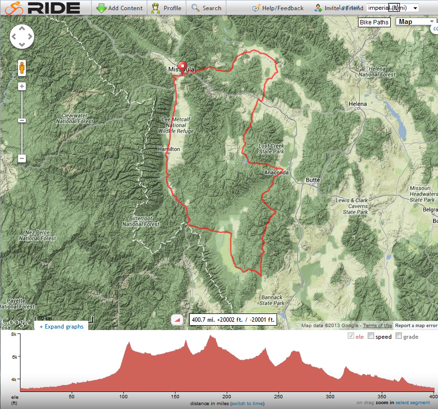
In July 2013 Linda and I rode the Montana Bicycle Ride, a 400-mile loop out of Missoula, Montana, organized by Bicycle Rides Northwest. The route included 6 days of cycling from campsite to campsite and one layover day.
20 July (Saturday)
We arrived in Missoula and checked in on Saturday, July 20, joining about 270 other riders. We spent the night at the Sentinel High School grounds and left our car there for the week.
21 July (Sunday)
On Sunday we rode 72 miles from Missoula south to Darby along the Bitterroot Valley. I enjoyed the view of the Bitterroot Mountains to the west. Each peak seemed to be a ramp separated from the others by a deep valley.
This was a warm day and it was getting hot when we arrived early afternoon at the Darby School. We were fortunate to find a tent spot on the school grounds that promised shade later in the afternoon.
22 July (Monday)
On Monday morning we rode south and climbed to Chief Joseph Pass (7241′), passing over the Continental Divide. This was a long climb and I was glad to complete it early in the day. The long descent east from the pass was a joy. We had nice forest scenery, smooth pavement, a tail wind, and easy riding.
The country opened up as we descended into the Big Hole Valley and the town of Wisdom. The cycling became more tedious in the warm afternoon. After 75 miles we camped for the night. Our camp was in a fresh-cut field at a working cattle ranch just north of Jackson.
23 July (Tuesday)
The night-time and early morning temperatures had been mild so far on the ride. We were not using the tent fly at night. The next morning, Tuesday, it was quite cold before the sun rose above the peaks to the east. I put on all my cold-weather bicycling clothes before leaving camp. We used the tent fly the remaining nights of the tour.
We rode south through Jackson and the Big Hole Valley, hearing the mooing of cattle being moved through distant pastures. I rode into sunshine just before climbing out of the valley. It quickly warmed up as I climbed to Big Hole Pass (7400′).
From Big Hole Pass we enjoyed a fast and consistent descent into Grasshopper Valley. Then we turned north on the Pioneer Mountains Scenic Byway. We climbed along Grasshopper Creek to a high divide (7800′), then descended along the Wise River. After riding about 65 miles we entered the tiny town of Wise River for our next campsite.
24 July (Wednesday)
The next morning was cold as we rode west along the Wise River in the shaded valley . There was a cold head wind moving down the valley floor. It quickly warmed up after we turned north on a lightly-used forest road. We climbed to a pass with views of the Anaconda Range to our west. From the pass we descended to Anaconda. We followed the Pintler Scenic Highway past Georgetown Lake to Philipsburg for a 67 mile day.
25 July (Thursday)
Linda and I took Thursday, our layover day, off the bike. After breakfast we hiked a ridge trail east of camp, then visited downtown Philipsburg on foot. I enjoyed visiting the Philipsburg Brewing Company and drinking their Rye Pale Ale. We both enjoyed lunch at Friday Night Pizza. The rest day was well-spent; the break from riding refreshed us for the remaining two days of the tour.
26 July (Friday)
Friday started cold, as usual. The first 20 miles descended north along Flint Creek on excellent pavement and a tail wind. After passing east though Drummond we turned north and climbed over the Garnet Range. From there we descended into the Bitterroot Valley. The last 10 miles for the day was along a busy highway. We were glad to reach the tiny town of Ovando, our campsite after riding 66 miles.
27 July (Saturday)
Saturday, our last day of the tour, started cool. At first we experienced very little traffic on the highway as we rode towards Missoula along the Bitterroot River. The traffic picked up later in the morning. Fortunately the paved shoulder was wide enough to maneuver around rumble strips and slower riders without exposing oneself to traffic. After about 54 miles of riding we returned to our starting point of the tour. This completed a scenic and interesting route in part of Montana I had never before visited.

Planning a bike tour in Montana next summer with my wife [on our tandem] and friends, I read the description of your tour with great interest. The route you followed is similar to what we had in mind but I am concerned that some sections (e.g.: Polaris road between Jackson and Wise River) could be un-paved. Did some sections of your trip included un-paved routes and if yes, were the routes in good enough condition to ride with a “race” bike?
Thanks,
J-P
Hi J-P,
Neither Linda nor I recollect any unpaved sections on the route (except for some pull-outs where we had supported food stops or campsites). Your tandem “race” bike should do fine.
Best wishes for your tour,
Paul